A Brief History of Nassau County, Florida
Jan H. Johannes, Sr.
 This section of northeast Florida we call Nassau County has a fascinating history that dates to the mid-16th century with the arrival of Europeans along the east coast and our inland waterways. Native Americans, however, fished these shores and cultivated the land for thousands of years before the Spanish, French and English arrived. These were the Timucuan Indians that thrived in North Florida and South Georgia until disease, brought by the settlers, wiped them out.
In the 1550s, French explorers Jean Ribault and Dominique de Gourgues anchored their ships in Cumberland Sound. Ribault came as an explorer and colonizer. de Gourgues came to avenge massacres of the French Huguenots.
Spanish explorer Pedro Menendez founded St. Augustine in 1565 and two years later built a small fort at the north end of Amelia Island. This tells of our antiquity in relation to the nation’s oldest continually occupied city.
Spanish influence dominated the island and mainland Nassau County throughout the 16th and 17th centuries, up until 1763, which was the first of two Spanish colonial periods in Florida history. Santa Maria was the name given the island (Amelia) and small settlement as it took on the role of outpost of the Spanish colonial capital of St. Augustine. Spanish settlers gradually moved inland and settled the St. Mary’s and Nassau Rivers and their small tributaries, populating the land of the Native American.
Passing into the 18th century, Native American tribes shifted as European settlers increased. Carolina tribes moved south. The Uchees of the Muskogee tribe settled along the St. Mary’s River but the Seminoles moved on south.
To the north were the English colonies of Georgia and the Carolinas and to the west were the Louisiana and Mississippi Valley French, each considering the other intolerable. Locally, the St. Mary’s River took on the role of a buffer between the Spanish and the English.
Florida was transferred to the British by the Treaty of Paris in 1763, with the Brit's then controlling all of the American east coast. It brought to Florida the plantation system that would survive for nearly 100 years. The British began a program of development and construction; planning the community of Bermudas at what is now Crandall Campgrounds. A highway was constructed from the northern colonies to St. Augustine, crossing the St. Mary's River, extending south through what is now Callahan and Jacksonville.
In the mid-1770s, came the American Revolution. To the north, Georgia and the Carolinas were part of the thirteen colonies that would become the United States of America. From those states would come the American Patriots probing across the St. Mary's River in an attempt to disrupt and unseat British control.
The British constructed Fort Tonyn in 1776, of timbers and earthworks, a mile east of the King’s Road crossing at Kings Ferry. Lightly defended, the British abandoned it with the advancing Georgia militia and federal troops, moving south along Kings Highway to a bridge at Alligator Creek (Callahan). There they were joined by British troops from St. Augustine and repelled the American troops that had followed from the St. Mary’s. This was the last of the American forces until after the turn into the 19th century. The battle at Alligator and another at Thomas Creek off of the Nassau River, were the only Revolutionary conflicts to take place in today's Nassau County.
By 1783, Florida was again transferred back to the Spanish bringing a greater sense of peace along the St. Mary's. A land-grant system was re-established and the plantation system continued. By 1790, Spanish colonial rule effectively fostered the first real land boom.
The first fifteen years of the 19th century brought pirates, bandits, rascals, slave runners and foreign intervention to Amelia Island and the mainland. The Jeffersonian Embargo of 1807, restricted American ships from engaging in foreign trade, especially the importation of slaves. Amelia Island and Fernandina then became a preferred slave smuggling port. The population of Fernandina rapidly grew and some accounts claim as many as 150 sailing vessels would be anchored in the harbor.
In 1821, Florida was ceded to the United States and with that this land of ours became a part of Duval County. It would be 1824 before Nassau County would break away as a county unto itself. Though Fernandina was named the county seat, the town was in a growth slump that, in 12 years, would force the relocation of the seat of government to Sand Hill on the mainland.
By the 1830s there were few roads through the pine forests of mainland Nassau County. The Kings Road went north to south and trails and paths connected the small settlements along the St. Mary’s and a few of its tributaries.
The county seat remained at Sandhill until after Civil War broke out and Union troops landed on Amelia Island. For the safety of county records the county seat was moved further inland to a point on the King’s Road between today’s Hilliard and Callahan. It remained there until Union forces arrived and forced return of the records to Fernandina.
Senator David Yulee established the railhead of the Florida Railroad at Fernandina in 1853 as the headquarters of the Atlantic to Gulf of Mexico railroad. The first major obstacle of getting the rails to what was Fernandina, now Old Town, was that the rails could not cross a large swamp south of the old town. Land was purchased just south of the swamp and a new plat was drawn.
Construction began on the rails in 1854 at new Fernandina's Centre Street, then headed south several miles to a narrow stretch of the Amelia River and onto the mainland. This first segment took a full year to complete. The road was completed to Hart's Road (Yulee) and as far as the Kings Highway by mid-1856 and to Bryceville by late fall.
Along the rails, settlements sprouted. At King’s Road one young settlement and Sharon Baptist Church existed since the 1840s. There construction foreman Daniel Callahan elected to build a railroad supply camp from which would spring a small transportation junction. Hart's Road (Yulee) was the name given to the settlement that sprouted out of the intersection of the Florida Railroad and Hart's Road, the Jacksonville to St. Mary's, Georgia road, built about 1840,.
The American Civil War broke out in Charleston harbor in 1861 which, in turn, brought a Union invasion of Amelia Island the following year. Most of the town's population had taken the last trains to Waldo and Florida's interior. Union troops commenced to destroyed the railhead, offices, rolling stock and removed the rails up to the mainland. With many wealthy landowners leaving the area, slaves were released from bondage and scattered to their own settlements such as Franklintown on the south end of Amelia Island.
Following the war reconstruction was somewhat gentler than in many communities of the South. Railroads were repaired, lumber mills were constructed along the tracks and small settlements began blossoming in all sections of the county. Lumber mills expanded at Kings Ferry and Orange Bluff and eventually every 5 miles or so along the rails. Narrow gauge lumber railroads crisscrossed the county, delivering long leaf yellow pine to the mainline and rivers.
Communities began to shine with the burgeoning of the Victorian era. Fernandina built large Victorian style mansions as homes in the county's interior took on a country Georgian look with broad porches and a dash of gingerbread. The first non-railroad bridge was constructed a quarter of a mile north of the present A1A bridge.
By 1881, the Savannah, Florida & Western Railroad from Waycross to Jacksonville was completed through Boulogne, Callahan and south. The Hilliard & Bailey lumber mill moved its operation from the river to a point on the new SF&W and the Town of Hilliard was born.
The turn into the 20th century brought local development of the modern shrimping industry. Amelia Island sailors and their mainland partners designed and built the nets, haul seines, and trawl prototypes that developed into the international fleets of today.
The yellow pine and timber industry had been a successful venture of a large percentage of county residents by the 1930s. After almost 100 years, however, the yellow pine was exhausted. The Rayonier Corporation of Shelton, Washington turned their attention to southern pine and the processing of pine pulp. Container Corporation began construction Amelia Island of a pulp mill the same year of 1937 - both plants generating income for hundreds that were out of work during bad economic times.
In Yulee, in 1954, the Terminal Bag Corporation constructed a 300-thousand square foot packaging facility that operated for more than 40 years. It employed about 300 and was an economic boost to that community.
In Hilliard, the then Civil Aeronautics Administration began construction of a six million dollar air traffic control centerthat would control civil and military aircraft in five southern states. Completed and manned by about 400 well trained employees, the 54,000 square foot facility is one of twenty-two such enroute centers of today's Federal Aviation Administration.
A Florida Nonprofit 501(c)3 tax Exempt Organization
West Nassau Historical Society - West Nassau Museum of History
Located Inside the Historic Train Depot at 45383 Dixie Avenue, Callahan
Mail to P.O. Box 1758, Callahan, FL 32011 (904-879-3406)
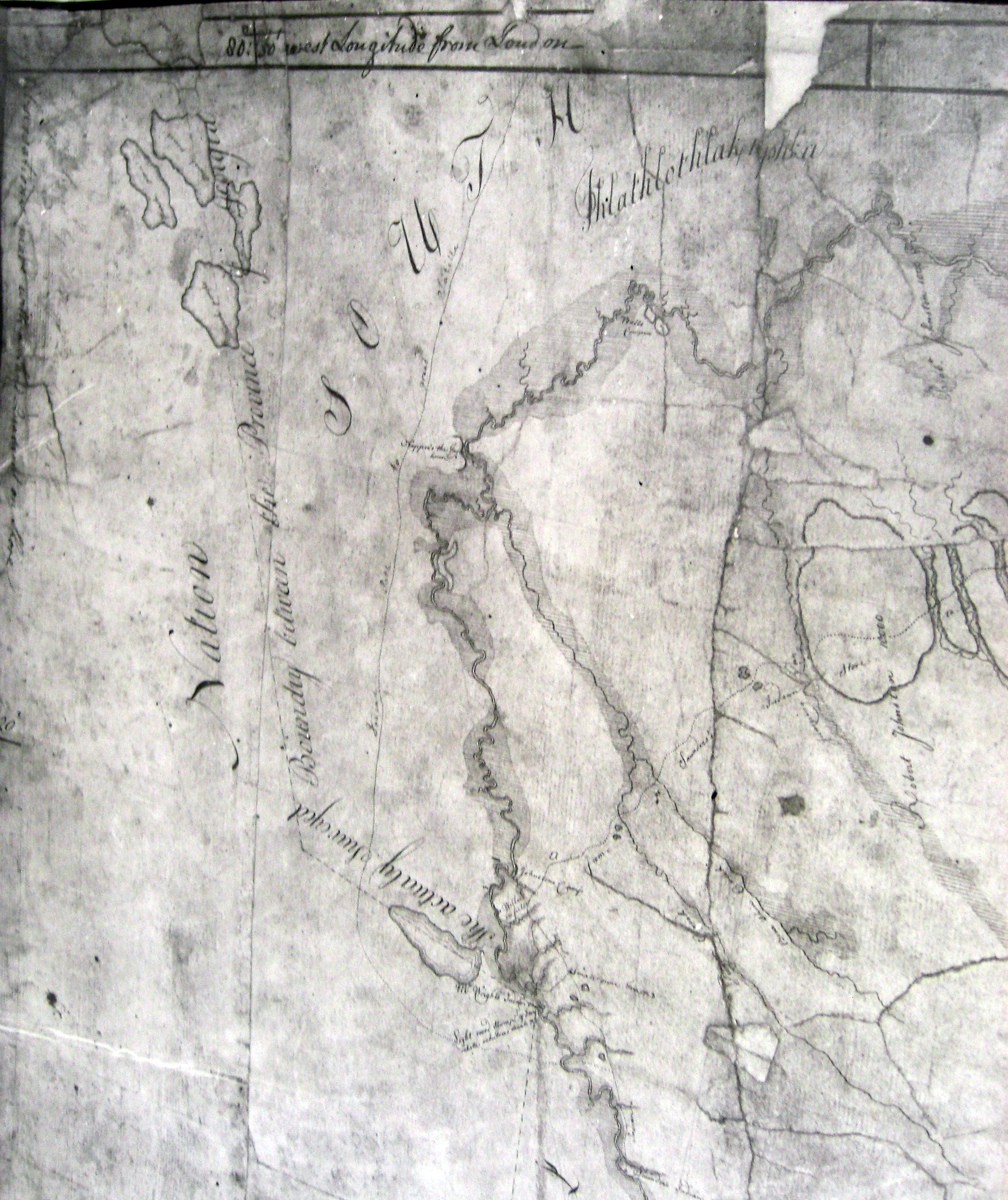
A very early map dating from the mid-1700s of the St. Marys River from about Colorain at the top right, West to Trader's Hill, then south along the river to St. George, Georgia.
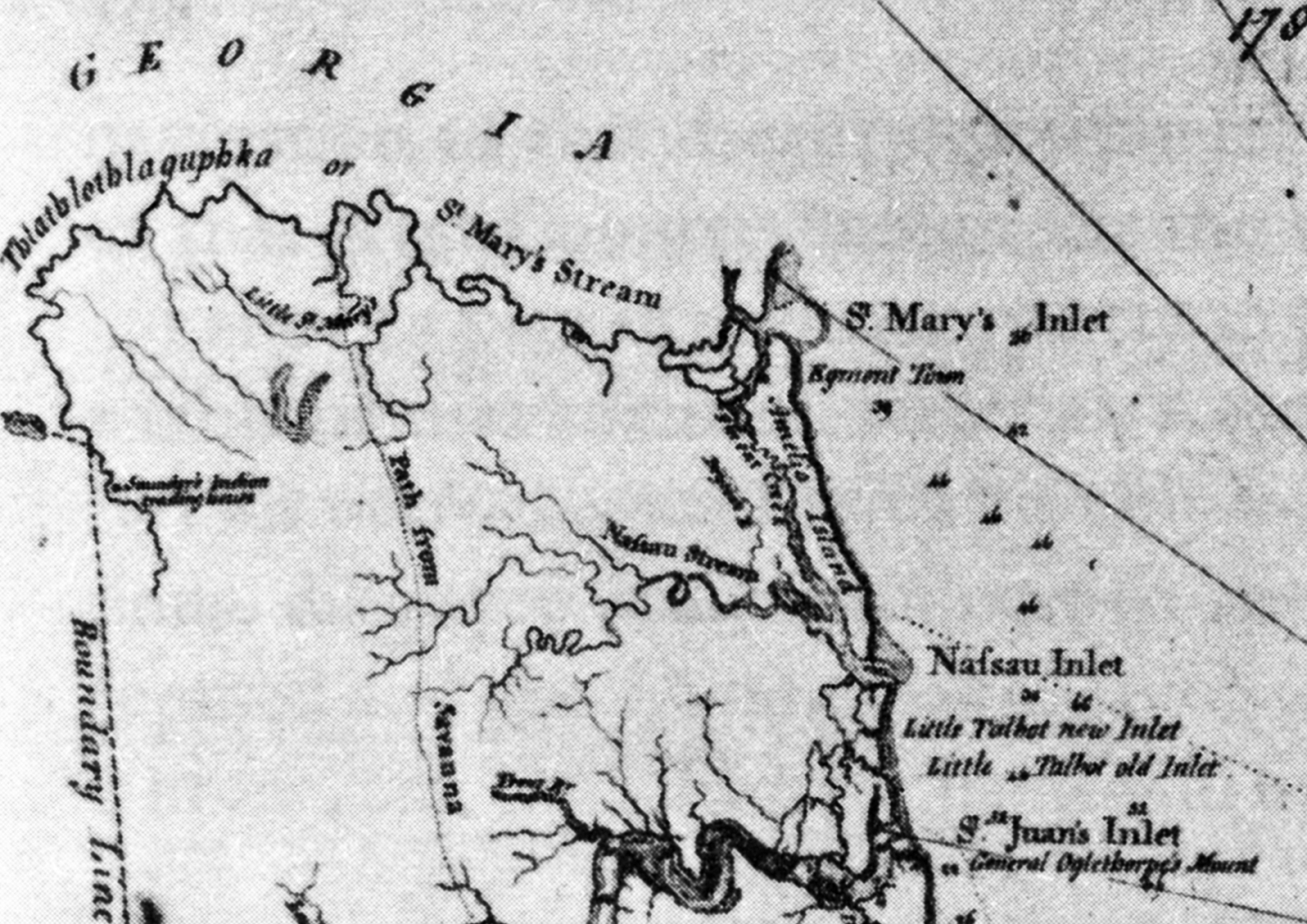
Circa 1780 during the British occupation of Florida. The British controlled Florida from 1763 until 1783 when Spain regained control lasting until 1821. It was than transferred to the United States and remained a territory until statehood in 1845.
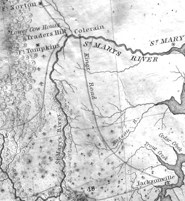
Circa 1834 when Colerain and Trader's Hill in Charlton County, Jacksonville in Duval County and the King's Road were the features of the early map.
Historic Maps of Nassau County